During the Anglo-Nepal War (1814-1816), the Kali River Theatre was a part of the British East India Company’s campaign in the western frontiers between the Kali and the Sutlej Rivers. Including an elaborate plan to capture Kumaon, the British looked to chase away the Gorkhas with the help of chiefs who had been defeated by the latter about 25 years ago. These battles were important because whoever won them would eventually win the war.
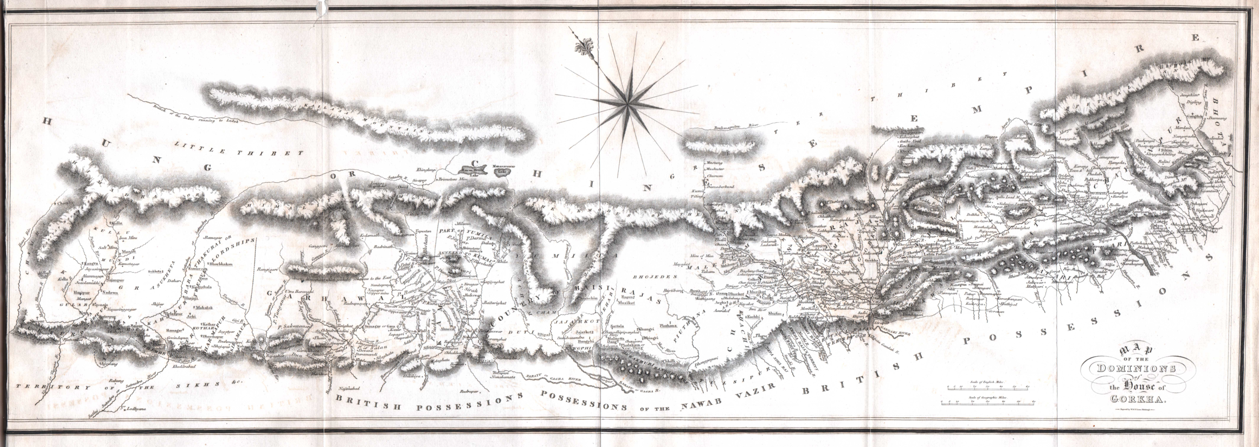
Map of the Dominion of the House of Gorkha (in Hamilton, 1819)The Anglo-Nepal War, 1814–1816
Primary source: East India Company, 18241
The Kali River in the Anglo-Nepal (1814-1816) War
Battles and Treaties around the Kali River, fixing it as Nepal’s western boundary.
Background: causes of war
1801–1813
Border skirmishes on the Gorkha2– and British-claimed Terai
Nepal and the British EIC both claim the plains of Butwal, Sheoraj, and frontier villages in Gorakhpur and Sarun. The EIC records show 18 years of failed diplomatic remonstrance before war becomes unavoidable.
pp. 676–684
1 October 1809
Ranjit Singh signs Treaty of Amritsar with the British
The Sutlej river is fixed as the boundary between the Sikh Empire and British-protected territory. Nepal has reached the Sutlej at its maximum western expansion. Three powers now converge on that river.
External Context
29 May 1814
Butwal massacre, the immediate casus belli
Gorkha troops kill 18 British police officers at Butwal at a newly established post. The EIC, having exhausted diplomatic options, prepares for war. Lord Moira3 (Governor-General) begins assembling the campaign plan.
pp. 684–686
August–October 1814
British intelligence gathering and strategic design
Dr. Buchanan, Moorcroft, Hearsey, Fraser and Rutherfurd produce intelligence reports on Kamaon4, Garhwal, Tibet passes, the Kali river course, and Chinese intervention risk. The Kali as a boundary is contemplated before operations begin. The Tartary trade corridor through Kamaon is identified as a strategic prize.
pp. 44–104
27 September – October 1814
War declared; four-division campaign plan issued
J. Adam (Secretary to Government) issues campaign instructions to Gillespie (2nd Division, Dehra Dun), Martindell (replacing Gillespie), Marley (4th Division, eastern Nepal), Wood (3rd Division, Gorakhpur), and Ochterlony (1st Division, Sutlej hill states). The western theatre objective is the expulsion of Gorkha power west of the Kali.
pp. 62–70, 92–101
First campaign: October to December 1814
27 October 1814
Timley Pass seized; Dehra Dun occupied
Gillespie’s division successfully seizes the Timley Pass into the Dehra Dun valley — the first British success of the war. The Dun and town of Dehra fall without resistance. Gillespie advances on Kalunga fort.
pp. 435–436
31 October 1814
First assault on Kalunga: Gillespie killed
Four columns assault the fort of Kalunga (Nalapani), held by Bulbudder Singh [Balbhadra Kunwar] with ~500 Gorkha troops. The attack is repulsed with heavy losses. Major-General Gillespie falls at the wicket of the fort, the war’s most significant British death. ~200 British killed and wounded against a garrison of 500.
pp. 437–443
5 November 1814
Ochterlony takes Nalagurh and Tarragurh
In the western theatre, Colonel Ochterlony (now Brigadier) captures the forts of Nalagurh and its dependent post Tarragurh in the Sutlej hill country. It’s the first actual British success in the war. He begins methodical reduction of Ummer Sing Thappa [Amar Singh Thapa]’s fortified chain.
pp. 453–456
27 November 1814
Second assault on Kalunga repulsed again
Colonel Mawbey (now commanding) launches a second assault after artillery breaching. The attack again fails — bamboo stakes at the breach foot, devastating fire from loopholes, and near-vertical approach defeat the columns. Heavy British casualties again. At night, the British cut off the water supply to the fort.
pp. 466–467
30 November 1814
The Gorkhas leave Kalunga under cover of darkness
Reduced by thirst and casualties, Bulbudder Singh’s garrison evacuates Kalunga by night. British troops enter the burnt fort. Bulbudder escapes wounded. 95 Gorkha dead are found inside, with almost all principal officers dead. The garrison’s heroic resistance becomes legendary on both sides.
pp. 473–494
December 1814
Gardner begins political campaign in Kamaon
Lieutenant-Colonel W.L. Gardner and the Honourable Edward Gardner begin raising irregular forces in Rohilkhand for a Kamaon expedition. First letters exchanged with Bum Sah, the Gorkha Soobah of Kamaon, exploring the possibility of his defection. Intelligence reveals Bum Sah’s personal resentment of the Thapa faction at Kathmandu.
Ramgarh heights are taken without opposition on 11 February; Ramgarh fort surrenders on 16 February; Jhoojooroo fort surrenders on 17 February. Ochterlony has now snapped three major links in Ummer Sing’s defensive chain. Supply routes to Malown are severed. Ummer Sing concentrates his remaining force at Malown, his last defensible ridge.
pp. 632–633
2 March 1815
Intercepted Gorkha letters: Nepal petitions China for military intervention
British forces intercept and translate letters from Ummer Sing to the Rajah of Nepal, including a draft petition to the Emperor of China seeking military assistance. The petition warns China that British conquest of Nepal will be followed by invasion of Tibet via Budrinath and Manasarovar passes. China never responds militarily. Ranjit Singh simultaneously rejects Gorkha overtures for alliance.
pp. 555–559
11 March 1815
Taragurh evacuated; Chumbah surrenders (16 March)
Gorkha forces abandon Taragurh. Days later, Chumbah fort surrenders, its garrison taken prisoner. Ummer Sing is now confined to Malown, completely isolated. The Rajah of Bilaspur, who had supplied the Gorkha army, is compelled by British military pressure to abandon his Gorkha alliance.
p. 633
Nights of 14–15 April 1815
Night operations at Malown: the decisive blow
Ochterlony launches coordinated night movements by Thompson’s, Showers’s, Bowyer’s, and Dunbar’s detachments to seize the heights above Malown simultaneously. The plan is guided by Lt Lawtie’s intelligence work (Lawtie is killed in the operations). By dawn on 16 April, British troops stand above the Malown ridge. Fort Soorujgurh and southern stockades are evacuated.
pp. 591–598
16 April 1815
Ummer Sing’s personal counterattack repulsed
Ummer Sing leads a personal assault on the British position at dawn. Described as “a most desperate attempt directed by the Goorka commander in person.” It is repulsed, but British losses for the two nights total ~180 killed and wounded. Ummer Sing is now surrounded, out of supplies, and without allies. Negotiations begin immediately.
pp. 591–598
23 April 1815
Major Patton defeats Hustee Dull Sah at Gunna-nath
In the Kamaon theatre, Nicolls sends Major Patton on a night march against Hustee Dull Sah (Bum Sah’s brother), who has taken position at Gunna-nath Pass north of Almora with the elite of the Kamaon garrison. After a sharp action and pursuit over several hills, Gorkha force completely defeated and dispersed. Hustee Dull withdraws into Almora. The province’s last field force is broken.
pp. 573–576
25 April 1815
Almora stormed; the Kamaon capital falls
Colonel Nicolls directs the assault on Almora’s fortified heights. Captain Faithful’s battalion storms successive breastworks; Captain Leys’s flank battalion cooperates with “intrepidity and judgement”. The heights and town fall by assault. A Gorkha night counterattack on 25–26 April is repulsed. Hasti Dal Shah is killed. Bum Sah’s position is now irretrievable.
pp. 585–587
27 April 1815
Almora Convention signed; Gorkhas retire across the Kali
Bum Sah signs the Convention with Gardner and Nicolls: surrender of Almora and all Kamaon fortifications in exchange for permission to retire unmolested across the Kali with arms, family and effects within 10 days. Fort of Lalmaudi handed over immediately as pledge. The crossing point is Jhool Gaut on the Kali — the 30-foot-wide gorge described in Rutherfurd’s 1814 survey. “The whole province being in our possession and the enemy withdrawn across the Kali.” Kamaon formally annexed.
pp. 570–572
15 May 1815
Ummer Sing surrenders at Malown; western armies retire across Kali
Ummer Sing Thappa surrenders Malown to Ochterlony on terms: he and Runjore Sing (at Jytuck) permitted to retire with arms and two guns; all Gorkha troops in Garhwal to evacuate across the Kali by the Kamaon route. All forts and posts west of the Jumna surrendered. “The entire extinction of the Goorka power throughout the countries to the westward of the Kali or Gogra, involving the loss of more than a third of their Dominions.”
pp. 607–611, 635–637
Peace negotiations: June to December 1815
1 June 1815
Moira’s victory despatch states boundary and Tartary rationale
Lord Moira’s Secret Letter to the Secret Committee articulates the full strategic case: the Kali is “the shortest and most defensible line of frontier from the snowy ridge to the plain”. ” Kamaon’s Tartary road through the Himalayan passes is “a commodious road into Chinese Tartary”, securing shawl-wool trade and overland communication with Beijing. The eastern boundary of Kamaon is fixed as the Kali, “which rises in the Snowy Mountains and pursues nearly a direct southerly course to the plains, where it assumes the name of the Gogra.”
pp. 551–584
June–July 1815
Moira’s peace terms transmitted with Kali as western boundary of Nepal
Draft treaty terms sent to the negotiating team under Lieutenant-Colonel Bradshaw. Key demands: perpetual exclusion of Gorkha from all territory west of the Kali/Gogra (Article 5 — “requires no remark”, meaning uncontested); cession of Terai lowlands Kali to Teista (Article 3); guarantee of Sikkim Rajah with Mechi as Nepal-Sikkim hill boundary (Article 4). Bradshaw instructed to make Siccim guarantee “indispensable”. The British negotiate with both Bum Sah and later Gujraj Misser as Kathmandu’s plenipotentiary.
pp. 763–818
27 June – July 1815
Negotiations at the Kali; Gorkha reluctance on Terai cessions
Gardner holds extended conferences with Bum Sah and his brother Roodher Beer Sah on the banks of the Kali River. The Gorkha side accepts the Kali as Nepal’s western limit without serious contest (“the loss of the territory to the west of the Kali would be purchasing a peace at a cheap rate”) but resists Terai cessions in the east. Bum Sah privately expresses fear that his surrender of Kamaon will be treated as treason at Kathmandu.
Moira reduces eastern Terai demands as leverage runs short: full cession Kali–Rapti; partial Rapti–Gandak; only Mechi strip east of Kosi (for Sikkim access). Morung partially conceded. Final draft treaty sent. Nepal still delays; the Kathmandu court is unwilling to ratify. The British assemble a second campaign force under Ochterlony to compel ratification.
pp. 848–868
2 December 1815
Treaty of Sugauli signed by Gujraj Misser
Nepali plenipotentiary Gooroo Gujraj Misser signs the Treaty of Sugauli with Lieutenant-Colonel Bradshaw. Nepal cedes: all territory west of the Kali; the Terai strip from Kali to Rapti and portions east; Sikkim to be restored under British guarantee; British Resident at Kathmandu; Nepal to hire no Europeans without British consent. The Kathmandu court then refuses to ratify.
pp. 869–886
Settlement: 1816 and after
January–February 1816
Second campaign force assembles — Nepal compelled to ratify
Ochterlony advances a second campaign force toward Kathmandu. Facing military reality, Nepal ratifies the Sugauli Treaty on 4 March 1816. British forces withdraw. The Kali becomes Nepal’s permanent western boundary. Nepal loses Kamaon, Garhwal, the Sutlej hill states – more than a third of its dominions accumulated over 30 years of conquest.
pp. 900–961
4 March 1816
Treaty of Sugauli ratified; boundaries take legal effect
Nepal formally ratifies. The Kali/Sardah river is established as Nepal’s western boundary “from its source on the Snowy Mountains” to the plains. The 1860 boundary survey will use both names together: “the River Kali or Sardah.”
pp. 908–961
6 August 1816
Moira’s definitive strategic retrospective
“The only solid policy was to fix on a river, the banks of which were of a strength to be guarded by a moderate force against any efforts of the enemy, and to make that river a line of separation from the snowy ridge to the plain. The Kali, which severs the Goorka possession nearly in two, was the feature required.” The Kamaon-Tartary overland corridor to Beijing is named as converting the China threat into a strategic asset, reducing Canton Viceroy’s leverage over the tea trade.
pp. 999–1000
1857–1860
Nepal’s loyalty in the rebellion; Terai partially restored
Jung Bahadur Rana sends Nepali forces to assist in the recapture of Lucknow during the 1857 rebellion. In recognition, the Treaty of 1860 restores to Nepal the Terai lowlands between the Kali and the Rapti ceded under Sugauli. The Kali remains unchanged as Nepal’s western boundary. Article 1 of the 1860 treaty confirms “all previous treaties” anchoring Sugauli permanently.
Treaty of 1860 — external
Present
The Kalapani dispute: Sugauli’s unresolved headwaters
The 1816 treaty text names “the River Kali” without specifying which of several source streams constitutes the Kali at high altitude near Kalapani and Lipu Lekh. The 1860 survey did not extend to the headwaters (then uninhabited and strategically unimportant). The 1824 document’s Rutherfurd survey (p. 104), “from its source on the Snowy Mountains”, and the passage on p. 572 (exploring whether to demand territory east of the Kali if the Tartary route required it) are primary documentary evidence of what the British understood the boundary to be at the moment they drew it.
pp. 104, 572, 764
Footnotes:
The British East-India Company was administered by the Governor-General Francis Edward Rawdon-Hastings, (styled 1st Marquis of Hastings, 2nd Earl of Moira). The spellings for places and names are used as they are in the papers [see: References].
Gorkha/Goorka and Nepal are used interchangeably in the document.
Hastings and Moira are used interchangeably in formal letters.
Both spellings: Kamaon and Kumaon appear in the document.
References:
Administration of the Marquis of Hastings. (1824). Papers Respecting the Nepaul War: Printed in Conformity to the Resolution of the Court of Proprietors of the East-India Stock, of the 3d March 1824. Great Queen Street: J.L. Cox. Retrieved from pahar.in.
Hamilton, F. (1819). An Account of the Kingdom of Nepal and of the Territories annexed to this dominion by the House of Gorkha. London: Edinburgh. Retrieved from pahar.in.
Mainali, M. (2023). Mukam Ranamaidan. Kathmandu, Nepal: Book Hill.

Leave a Reply