Table of Contents
1. Introduction
Nepal is not merely a country that experiences earthquakes; it is a land shaped by them. Situated at the collision boundary where the Indian plate underthrusts the Eurasian plate, the Himalaya is a zone of relentless tectonic strain. Earthquakes here are not anomalies or freak disasters. They are the earth’s periodic response to centuries of accumulated stress, inevitably released in a long seismic cycle.
Over time, these releases have lifted river terraces, fractured valleys, redirected rivers, and repeatedly tested human settlement. To understand seismic risk in Nepal, one must look beyond individual disasters and adopt a long historical lens. The great earthquakes of 1255, 1833, 1934, and 2015 are not isolated events; they are chapters of the same geological story.
2. The 1255 AD Shock
The earthquake of 1255 AD, identified by paleoseismologists as a “giant” Himalayan rupture, remains one of the most destructive events in Nepal’s history. Medieval chronicles record the death of King Abhaya Malla, along with thousands of others. This was not a local tremor but a rupture capable of reshaping the Himalayan front.
Modern geology confirms what chronicles only hinted at. Paleoseismic trenches reveal sharp contacts where older Siwalik sandstones are thrust over younger river gravels, evidence of surface rupture. Radiocarbon dating of detrital charcoal shows that the steep escarpments along the Main Frontal Thrust (MFT) were not formed by a single earthquake but cumulatively, through repeated events such as 1255 and later 1934.
There is debate about an even earlier rupture around 1100 AD, inferred from carbon dates at the Mahara River. Some researchers suggest this represents a separate earthquake; others argue it may be a dating overlap with the 1255 event. This uncertainty highlights a dual challenge of seismic history: geological time is more probabilistic rather than precise, while historical memory is fragmentary and selective.
The society did not forget the trauma of 1255. It survived in religious narratives and collective memory, lying dormant until the earth reminded the valley again.
3. 1833: When the Earthquake Was First Carefully Observed
On the night of August 26, 1833, Nepal experienced its first earthquake documented in detail by Western observers. Dr Archibald Campbell, an assistant surgeon, left a remarkably careful account. He compared the sensation of shaking to standing on a raft or a ship at sea, where walking was nearly impossible without staggering.
Campbell distinguished between two types of motion: horizontal “undulatory” waves and sharp vertical jolts. His most telling observation came from a “good-going clock” that stopped at 10:58 PM, its pendulum swinging distinctly north–south, offering rare insight into the directionality of ground motion.
The damage was extensive. In Bhaktapur, nearly one-third of the city was destroyed. Temples and tall masonry structures collapsed in Kathmandu and Patan. Yet the Pasupatinath Temple survived unscathed. To many, this was divine protection. Structurally, however, its survival can be explained by robust brickwork and well-distributed mass, suggesting that construction quality matters more than architectural age.
Geologically, the 1833 earthquake behaved differently from later events. It is now understood as a blind thrust earthquake, with rupture confined to depth and no major surface break. This explains the severe shaking without the dramatic fault scarps seen in 1934.
4. 1934: The Great EarthQuake
The January 15, 1934 (Magh 2, 1990 BS) earthquake, remembered as the Great Earthquake (Mahabhukampa) and the basis for the National Earthquake Protection Day, is Nepal’s most transformative seismic event in the modern era. Brahma Shumsher, in his account, described the ground moving like waves in water, with such violence that standing was impossible and light bulbs were thrown from their sockets.
Originally assigned a magnitude of 8.1, modern studies suggest the rupture may have reached 8.4, extending 200–250 km along the Himalayan front. Unlike 1833, this earthquake produced clear surface ruptures along the Main Frontal Thrust. River terraces were uplifted by up to 6 metres at Tintale, and cumulative uplift at places like the Ratu River now totals over 45 metres, built across multiple earthquakes.
The landscape itself recorded the event: rivers were narrowed, floodplains shifted, and white Siwalik sandstones were thrust over young gravels. These visible scars helped scientists reconcile a long-standing problem—the mismatch between accumulated tectonic strain and the energy released by known earthquakes. The 1934 rupture filled a major gap in that seismic accounting.
5. 2015: Seeing the Earth Through Instruments
The 2015 Gorkha earthquake marked a turning point. For the first time, Nepal moved from reliance on human descriptions to instrumented seismic data. Peak Ground Acceleration maps revealed precisely how the ground moved and why certain areas suffered disproportionately.
One unexpected insight came from human behaviour. In Nepal and much of South Asia, people tend to run outdoors even during mild shaking (Intensity 3). This contrasts with European assumptions embedded in the European Macroseismic Scale (EMS-98), where people typically stay indoors at such intensities. Without accounting for this behaviour, damage and casualty patterns can be misinterpreted. Seismic science, it turns out, must also study people.
6. Structural Lessons Repeated Across Centuries
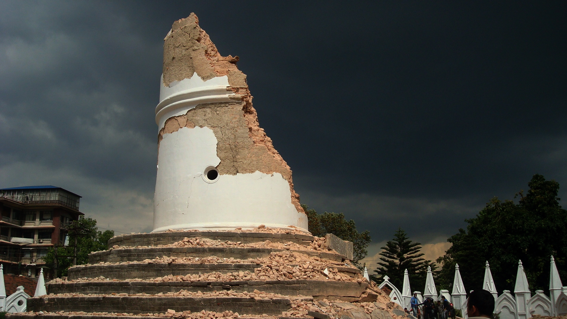
Across 1255, 1833, 1934, and 2015, the same pattern emerges: tall masonry structures fail first. Temples, towers, and pillars repeatedly collapsed, including the Dharahara and Ghantaghar, which have been destroyed and rebuilt multiple times.
Yet the story is not simply one of “old versus new”. Traditional Newar buildings, when well-constructed, often performed better than colonial-era “modern” houses, which were frequently rendered uninhabitable. Earthquakes in Nepal have consistently demonstrated that craftsmanship and structural logic matter more than architectural fashion.
7. Secondary Hazards: When the Ground Turns Hostile
Earthquakes in the Kathmandu Valley rarely act alone. The valley’s soft, water-saturated sediments—remnants of an ancient lake—amplify shaking and trigger secondary hazards.
In 1833 and 1934, ground fissures, sinkage, and dramatic liquefaction were reported. In 1934, fountains of water and sand erupted from the ground, rivers turned black with suspended sediment, and neighbourhoods cracked apart. Fires followed collapse, especially where timber and household flames mixed amid rubble. Liquefaction was also observed in eastern Nepal in 2015.
These cascading effects often cause as much harm as the shaking itself.
8. Memory, Forgetfulness, and the Challenge Ahead
Nepal’s history reveals a tension between resilience and amnesia. The country rebuilds but tends to forget the urgency of preparedness during long quiet periods. The proverb “Nine days a novelty, twenty days forgotten (Nau din ma naulo, bis din ma birsyo)” captures this perfectly.
Today, river terraces tilt southward under tectonic force. Faults cut cleanly through riverbeds. The geological warning signs are visible to anyone who looks. Yet effective preparedness depends not only on science but also on trust between engineers, masons, homeowners, and institutions.
Training local masons, designing evacuation routes that reflect real behaviour, and respecting both tradition and engineering are not luxuries. They are necessities.
9. Conclusion
The Himalaya will continue to rise, and earthquakes will continue to come. That much is certain. What remains uncertain is how well Nepal chooses to remember what the earth has already taught.
From medieval chronicles to digital seismographs, from uplifted river terraces to fallen towers, the message is consistent: earthquakes are inevitable, but disasters are not. Nepal’s enduring spirit has survived centuries of shaking. Its future safety depends on whether that spirit is matched by sustained memory, informed planning, and respect for the restless ground beneath its feet.
References
• Campbell, A. (1833). “Account of the Earthquake at Kathmandu.” Journal of the Asiatic Society of Bengal. Retrieved: pahar.in
• Grünthal, G. (ed.) (1998). European Macroseismic Scale 1998: EMS-98. European Seismological Commission, 100p.
• Hamal, C. (2082 BS). “‘भूकम्प’ सम्झनाभन्दा बिर्सना धेरै” (Earthquake: More Forgotten than Remembered). Gorkhapatra.
• Martin, S. S., et al. (2015). “Ground Motions from the 2015 Gorkha Earthquake.”
• Sapkota, S. N., et al. (2012). “Primary Surface Ruptures of the Great 1934 and 1255 Himalayan Earthquakes.” Nature Geoscience.
• Shumsher, B. (1934). Nepal ko Mahabhukampa 1990.
• Stacey, S.S., Hough, S.E., Hung, C. (2015). “Ground Motions from the 2015 Mw 7.8 Gorkha, Nepal, Earthquake Constrained by a Detailed Assessment of Macroseismic Data.” Seismological Research Letters, 86:6, pp. 1524-1532.
Leave a Reply